Plant Hardiness Zones

Plant hardiness and climate zones are designed to assist gardeners in identifying plant species suitable for their climate. The organizations that publish plant hardiness zone information rely heavily on historical data when preparing their maps and documentation.

The various hardiness and climate zones are a good place to start when selecting new plants, but the final decision should always be based on your individual garden environment.

USDA Plant Hardiness Zones

The 2012 version of the interactive USDA Plant Hardiness Zone Map shows in detail the lowest temperatures that can be expected each year in the Continental United States, Alaska, Hawaii and Puerto Rico. 

This edition of the USDA Plant Hardiness Zone Map (PHZM) is GIS (Geographic Information System)-based for the first time. This is also the first USDA PHZM that is specifically designed for the Internet. It enables viewers to examine plant hardiness zones at a much finer scale than ever before. For the first time, a very sophisticated algorithm was used to interpolate low-temperature values between actual weather reporting stations. A personal ZIP Code zone finder is also included with this version of the map. Simply type your ZIP Code in the proper box and your zone will be reported.

Zones in this edition of the USDA Plant Hardiness Zone Map (PHZM) are based on 1976–2005 weather data. A trial check did not find that the addition of more recent years of data made a significant difference in the definition of these zones. Each zone represents the mean extreme minimum temperature for an area, calculated from the lowest daily minimum temperature recorded for each of the years 1976–2005. This does not represent the coldest it has ever been or ever will be in an area, but it simply is the average of lowest winter temperatures for a given location for this time period.

Two new zones have been added to this edition of the USDA PHZM. Zones 12 and 13 have been introduced for regions with average annual extreme minimum temperatures above 50 degrees and 60 degrees F, respectively. They only appear on the maps for Hawaii and Puerto Rico.

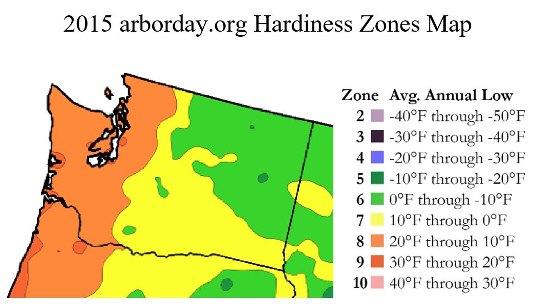
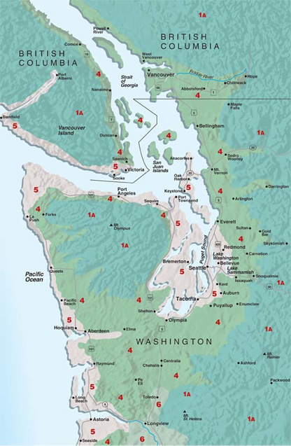
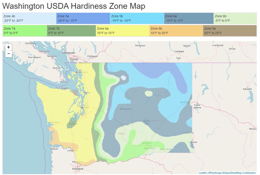
The majority of Grays Harbor and Pacific Counties, Washington, fall into USDA Plant Hardiness Zones 8a and 8b, which have an average annual minimum temperature range of 10 to 15 F and 15 to 20 F, respectively.

usda hardiness zone map washington state

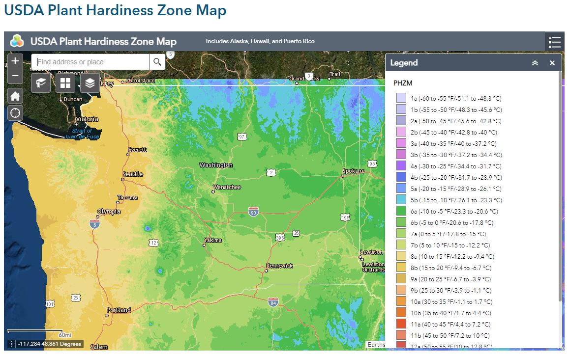
The concern with the USDA zones is that they are based only on average annual minimum temperatures, and do not take into consideration other factors which significantly impact horticulture, such as day-length, rainfall, frost, minimum and maximum temperatures, sunshine, and soils. The result is that large geographic areas of the US may be grouped together into a single USDA zone when, in fact, they actually have significantly different growing conditions. For example, while few would consider Aberdeen, Washington, and Dallas, Texas, as having similar climates and gardening conditions, both are in USDA Hardiness Zone 8a.


usda hardiness zone map washington state.

National Arbor Day Foundation Hardiness Zones

In 2015, the National Arbor Day Foundation published a new Hardiness Zone Map.  The new NADF zones are based on the most recent 25 years of data available from the National Oceanic and Atmospheric Administration’s 5,000 National Climatic Data Center cooperative stations across the United States. Compared to the 1990 USDA map, on the 2006 NADF map, many areas of the US have shifted at least one full hardiness zone in a warmer direction.

arbor day hardiness zone mapThe most significant difference between the USDA and NADF maps in our region is that the area immediately around Grays Harbor is in NADF Zone 9 (minimum low temperature of 30 to 20 degrees F), much warmer than USDA Zone 8a (minimum low temperature of 15 to 10 degrees F). The rest of Grays Harbor and Pacific Counties are in NADF Zone 8 (minimum low temperature of 20 to 10 degrees F), roughly the equivalent of USDA Zones 8a and 8b.

Like the USDA Plant Hardiness Zones, the National Arbor Day Foundation Hardiness Zones are primarily based on a single factor (minimum temperature), and thus are subject to similar concerns.

Sunset Climate Zones

The Sunset Climate Zones are yet another plant hardiness system. These are the climate zones used in Sunset’s popular Western Garden Book. Sunset’s Climate Zones take a wider range of factors into account than the USDA or NADF: growing season, timing and amount of rainfall, winter lows, summer highs, and humidity. The other systems tell you only where a plant may survive the winter; Sunset’s Climate Zones attempt to give you a better indication of how your plant will fare year-round. Most of Grays Harbor and Pacific Counties are in Sunset Climate Zones 4 and 5.

sunset-climate-zonesSunset Zone 4
Cold-winter areas of Western Washington and British Columbia. One of the West’s most narrow, linear climates, Zone 4 runs from high in the coastal mountains of Northern California to southeastern Alaska. It gets considerable influence from the Pacific Ocean, but also from the continental air mass, higher elevation, or both. As it extends north, the zone first touches salt water in northern Puget Sound. Average winter lows in Zone 4 range from 34°F down to 28°F, with extreme lows averaging 8 to 0°F. The growing season is 150 to 200 days long, but because Zone 4 summers are temperate (highs average from the low 60s to the 70s), plants take more time to develop. If you’re growing vegetables, for example, add at least 50 percent to the days-to-harvest figure listed on the seed package, or start your garden from transplants.

Many people know Zone 4 for the miles of tulips in the Skagit Valley. In fact, this area has more spring bulbs under cultivation than all of the Netherlands; the slightly colder winters of Zone 4 help induce dormancy in the bulbs. Zone 4 extends into the greater Seattle area.

Sunset Zone 5
Marine influence along the Northwest coast and Puget Sound. Mild ocean air moderates Zone 5. Summer highs run between 65 and 70°F along the coast, and between 70 and 75°F inland and around Puget Sound. Such mild temperatures favor leaf vegetables, which are slow to bolt, and flowering ornamentals like begonias. Steady breezes and lower temperatures, especially along the coast make windbreaks and warm microclimates critical for heat-loving plants.

Average January minimum temperatures range from 33 to 41°F, with annual lows averaging a few degrees colder, and 10-year extremes ranging from 20 to 6°F. Some locations (Coupeville, Raymond, Long Beach, Tillamook, Newport) get 10-year lows between 6° and 10°F, but much of the region, especially along the Oregon coast, is mild enough to let gardeners get away with growing plants like Washingtonia robusta and hardy forms of Agave americana. Big freezes do considerable damage when they come very early or very late. And while these occasional disasters clear the slate of most borderline plants, they should not serve as a general gauge of plant hardiness here. Though the growing season averages between 200 and 250 days, heat accumulation is low, and warm-season vegetables develop slowly.

Zone 5 includes the coastline areas of Washington and Oregon that are famous for lush vegetation. While not particularly warm in the summer (it’s hard to grow tomatoes in some areas), the long growing season favors flowering plants, such as fuchsias. Native plants of all types, including salal and Oregon grape (Mahonia aquifolium), thrive in this zone.

Resources

Scroll to Top